Hiking on the
Skyline Trail in Olympic National Park. This primitive trail leads you high into the Quinault River drainage. Then you walk in the mountains that divide the Queets and Quinault Rain Forests. It's an amazing adventure!
How We Hiked the Skyline Trail
We would use the Skyline Trail in part of
a greater hike across the Olympic National Park. We hiked on trails through the Olympic Mountains, starting in the north and ending in the south of the Park.
Using the Elwha Valley Trail we stared at the Whiskey Bend Trailhead, then we connected to the Skyline Ridge Primitive Trail and exited near Lake Quinault. The Elwha trail leads you for several days in a river valley, before climbing into the mountains at the Low Divide. From there we turned our toes uphill and started climbing into the Skyline area. I classify the Skyline to being the toughest trail on the Olympic Peninsula, so make sure you are prepared.
Want to learn more? Detailed guides to hiking the Olympic Mountains.
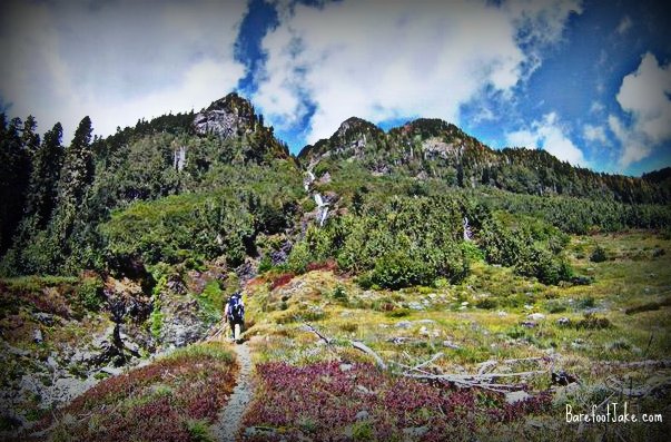
 |
| Preparing for our Olympic Mountain adventure - Photo by Jeremy Johnson |
Planning and Impressions of This Hike
Our trip was done mid-summer, during an above average heavy snow year. During our trip planning phase, we took into account that late season spring snow would still be in our route. We brought along trekking poles to aid us if we fell on the snow and needed to self-arrest.
Need help planning? Check out my guide for backpacking into Olympic National Park.
Looking back on this trip, it was such a landmark adventure. At the time it was the longest backpacking trip that I have ever completed. Aditionally, it was the first time I would
walk across the Olympic National Park. Also, it was the longest and most harsh terrain that I have ever
walked in minimalist footwear. This trip for sure tested us both physically and mentally.
I ended up breaking a 104 degree fever the night before we left on this adventure. Wanted to go on this trip so bad, I couldn't let being sick stop me. The first night of the trip I woke up with the inside my sleeping bag soaked with sweat. I'm sure my body was still fighting the fever. I would have to focus on hydration to keep my energy levels up to make the walk.
Day 1: Elwha Valley Trailhead to Elkhorn Camp
We got dropped off at the Whiskey Bend Trail head by my partners wife. The day was warm and the bugs were light. Took a few breaks with snacks adventuring
up the Elwha Valley. Snapped lots of photography and passed different groups heading out of the Elwha from various adventures.
 |
| A footbridge on the Elwha Trail |
We stopped at Elkhorn to talk to the Rangers. Both of them asked about my footwear and the GoPro camera that I was wearing. One of them also commented about my partner's camera. They kindly took the time to snap this photo below.
 |
| Bench at Elkhorn Camp - Photo by Jeremy Johnson |
Day 2: Elkhorn Camp to Chicago Camp
Breaking camp that we set up above Elkhorn; sleeping right next to the Elwha River. I had low energy levels venturing down the valley.
There was no lack of water crossing numerous little streams. At the time this was the most miles I ever walked in my minimal footwear.
We stopped for lunch Camp Wilder and walked to the river to get water. After eating and water refill we continued toward Chicago Camp. We forded a river between Camp Wilder and Chicago Camp.
We scared a Black Bear out of the area; while approaching Chicago Camp. I remember eating dinner with one eye always into the timber. That was the first Olympic Bear I've saw in the wilderness and had me a little on edge.
 |
| Camping at Chicago Camp |
Day 3: Chicago Camp to Low Divide (In a Storm)
We awoke (I would say around 3am) to the sounds of heavy rain drops hitting the dome tent.
I really regretted the fact that I had to climb out of my warm sleeping bag to break down camp. Knowing that I would completely get drenched for how hard it was raining. At the time I never carried
a lightweight rain poncho, but I have since them never leave home without one.
Once camp was broke we made a small ford of the Elwha at Chicago Camp. Because of the recent rains, the river had rose around 12" overnight. It still only was just over the knee so it wasnt too bad.
Not much photography was done this day, since it was raining so hard. The heavy rains caused most of my photos to turn out a bit blurry from all the moisture on the lens.
 |
| Low Divide |
It didnt take us to long to get up to the Low Divide camping area, but by the time we did....we were completely soaked from head to toe.
The following hours, 75 percent of the day was spend listening to the rain just pour on the top of the tent. Making sleeping a thing to get usto, but quickly took a handful of naps. Dozing in and out of consciousness most of the afternoon. Wish I would have brought earplugs.
Day 4: Low Divide to Lake Beauty
The rains stopped through the night and after the fog burnt off. The sun started to peek through the cloud cover with the first views of Mount Seattle. We took this time to lay out our gear to get it dry as possible, in the invaluable sun.
 |
| Drying our hiking gear in the sun - Photo by Jeremy Johnson |
After a short walk out of the Low Divide camp area and passing though the horse gates. We got our first mountain and flower covered meadow views. This was a huge moral booster after staring at trees and water for so long.
 |
| Starting the Skyline Primitive Trail near the Low Divide |
We made our way through various basins and creek crossings. Seattle Basin was most memorable for me. Taking a few breaks for snacks and I washed my footwear, where the trail joins Seattle Creek.
I will never forget is crossing a almost paper thin snow bridge. Because of the steepness of the surrounding area, we could not get around it with heavy packs, so we decided to go up and over it. It was a dangerous move, but it ended up working out; we were lucky.
 |
| Paper-thin snow bridge on trail - Photo by Jeremy Johnson |
 |
| Dangerous snow on the trail, during a heavy snowpack year (September) |
Coming up out of a draw, headed uphill with a light breeze in our faces. I was at the time leading and came around a hairpin section of trail. Scanning my eyes up to see a big black object standing about 10 yards ahead. I quickly yelled and spooked a medium size Black Bear of the trail. This was the second of the trip.
It was late in the afternoon while we made the last push before our destination for the night of Lake Beauty. A few miles before the lake, we navigated some tight and washed out sections of trail. This took us some extra time and energy climbing down tree roots.
 |
| Nearing Lake Beauty |
Arriving at Lake Beauty to make camp, we took a much needed freezing cold bath. I yelled as I plunged into the water; for how cold it was. Getting semi-clean was worth the freezing water temperatures. The bugs were also bad at the lake. Looking down at pant leg to find 15+ mosquito's that were trying to feed through my clothing.
Views of south
slopes of Mount Olympus and the Valhalla's made it all worth it tho. I plan on being back in 2012 to enjoy the views again.
 |
| Swimming in Lake Beauty |
 |
| Mount Olympus - Photo by Jeremy Johnson |
Day 5: Lake Beauty to Three Prune Camp
After a much needed sleep. We arose just before sun came up. Spent a short time getting a warm breakfast into our belly and begin pre-hydrating.
Climbing out of Lake Beauty was a real leg burner with sore muscles.
The trail side-hilled for a bit and then began the
Moonscape portion of the Skyline Trail. It was slow going navigating up and down the hillside. Cairn's made it easier, than just relying on map alone for navigating this section.
It was some time before we reached the
maintained trail again. I was relieved, since my feet were feeling the fatigue of the lack of conditioning.
 |
| Skyline Trail Olympic National Park at Promise Pass |
While taking a break (in the Pass shown above). I flipped open the hood of my pack to watching my Thermarest in slow-motion fall out and begin to roll down the mountain. It quickly picked up speed to hopping over a series of little sections of exposed rock. It lucky stopped about 5 feet from dropping off a pretty good cliff. I climbed down and had to retrieve the important piece of gear.
The day pushed on as we head toward our destination of Three Prune Camp. We arrived just as the sun was dropping behind the high mountain forest.
Tip: Make sure you pack lots of water between Kimta Peak and Three Prune. The streams dry up, as the snow melts away. I ran out for several hours, in the summer heat. Not good!
Day 6: Three Prune Camp to Irely Lake Trailhead
I slept like a rock that night. We awoke again before the sun came up to shove down a quick breakfast. I was excited for a big meal of real food and a hot shower. We passed a grazing Blake Bear in the meadow, a few minutes out of our campsite. That would make 3 total in this trip.
 |
| Skyline Trail intersects the Three Lakes Trail |
 |
| From Three Lakes you hike on the Big Creek Trail |
Arriving at the Skyline trailhead later in the afternoon smelly and tired. I had a real sense of accomplishment completing this journey.
When I was a young boy I pinned
a Park trail and campsite map onto my wall in my room. I usto day dream about crossing the Olympic National Park someday. Here I was reaching my dream!
 |
| End of the trip photograph. 30.7 miles of rugged Skyline terrain to Low Divide, then 28. 4 miles to Whiskey Bend on the Elwha (start) |
Overview: This trip will forever be in my memory. This being my first real accomplishment in the backpacking world. You should train your feet for months/years before attempting this
type of travel with heavy pack. I have since cut my pack weight in half. Some of the photos above are not owned by me. All rights for select photos go to Jeremy Johnson.
Updated in 2025 by
Barefoot Jake